Examples
As previously said, the FloodProofs modelling system is designed to assist decision makers during the operational phases of flood forecasting, nowcasting, mitigation and monitoring in various-sized catchments. The system is operational in real time in different basins on the whole Italian territory for the National Civil Protection Department and in some basins of Albania, Barbados, Bolivia, Guyana and Lebanon. It is also used for water management purposed by Italian hydro-power companies (Compagnia Valdostana delle Acque, CVA, ERG Power Generation). It is useful for managing hydro-meteorological hazard alerts and warnings for Civil Protection purposes. The main priority is the defence of the citizens, their goods and, in general, the safeguard of all that can be damaged by the ground effects of intense precipitation events. Water management companies employ this forecasting chain mainly for preventing damages to the hydraulic structures in the case of extreme precipitation events.
Italy
description here
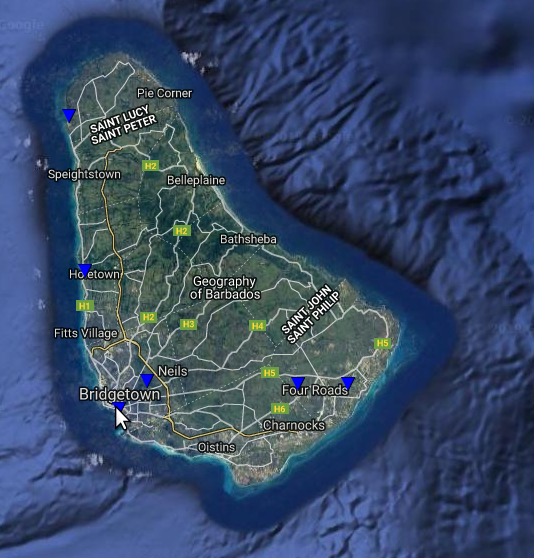
Barbados
The FloodProofs modelling system was implemented linking numerical weather predictions (CIMH WRF 4km), a stochastic rainfall procedure (RainFarm), real-time observations (rain gauges) and a fully distributed hydrological model (HMC). The flood forecasting chain is based on operational run of the HMC model.
- In the actual version of the flood forecasting chain, the discharges are generated by the HMC model using the following sources of forcing data:
CIMH WRF 4km, whenever a new run is available (deterministic forecast run);
rain gauges observation (nowcasting run);
rain gauges observation (initial conditions run)
- In addition, to improve the forecasting of rainfall events, the probabilistic part was added to accomplish operational probabilistic discharge forecast:
RainFARM based on CIMH WRF 4km, whenever a new run is available (probabilistic forecast).
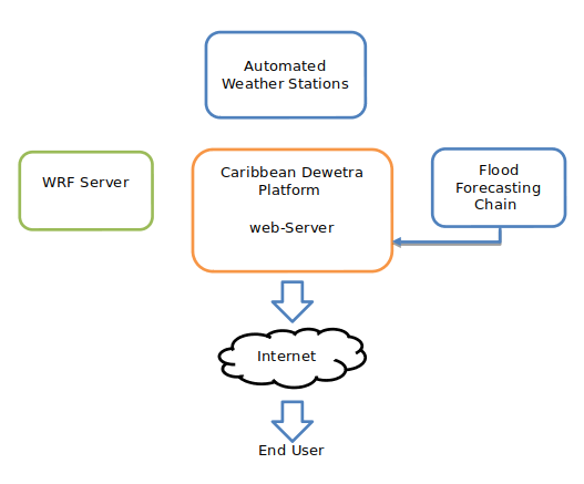
The food forecasting system is installed at the CIMH server room. It takes advantage of the existing CDP which stores and makes available all hydro-meteorological data to the different simulation lines. The workflow is shown in the following figure. Automated weather station data for time intervals ranging from 1 – 10 minutes are collected and stored in the CDP database. Similarly, new WRF outputs 00Z and 12Z runs are ingested into the CDP.
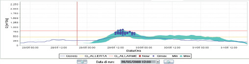
These data are utilized in the flood forecasting chain when required. The combination of weather station data and WRF data are utilized to run FloodProofs operational chain consisting of the HMC model and all required components. To perform a probabilistic discharge forecast we feed the ensemble of high-resolution fields provided by RainFarm to the HMC model. The benefits of applying RainFarm to the estimate of the uncertainty in flood predictions over small and medium catchments, becomes crucial for basins with areas smaller than a few hundred square kilometers. The outputs of FloodProofs for a probabilistic chain are reported in the figure above.
Bolivia
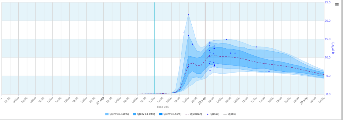
The FloodProofs system modellling run operationally at SENAMHI, and results are available to all the institutions involved in flood management at local and national level. The main components are a limited area meteorological model, which provides future rainfall fields, a stochastic downscaling model for rainfall and HMC fully distributed hydrological model, which transform rainfall into run-off. Flood-PROOFS ingests data and manages the model workflow needed for the hydro-meteorological forecast: meteorological models, real-time meteorological stations data, real-time data of the operation of regulating hydraulic structures and satellite data are considered in this process. It provides a quantitative evaluation of discharge and peak flow and evaluates the probability to exceed critical thresholds in critical outlet sections of the catchments.
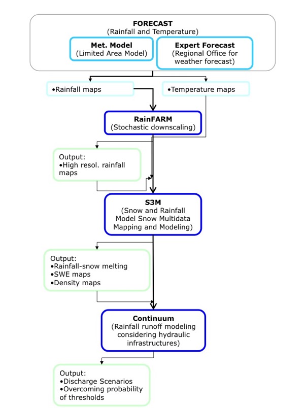
The system workflow is illustrated in figure above. Two different sources of forecast can feed the meteorological chain: a QPF by meteorological models (e.g. IFS, GFS, COSMO-I7, WRF) or the predictions issued by expert regional forecasters. The forecasters take into account different meteorological models, their knowledge of the territory and its climatic features to express QPFs in terms of accumulated rainfall on predefined areas and durations.
In both cases, QPFs are downscaled to a proper spatial and temporal scale using a stochastic downscaling model: RainFarm. It generates high-resolution (1 km and 30 min) precipitation ensemble forecast. The same approach, with some adaptation is applied to QPF given by regional forecasters. In both cases, it gives an ensemble of 50 downscaled precipitation forecast scenarios at the small resolution needed for hydrological applications. The third ingredient is the HMC hydrological model needed to simulate the streamflow caused by the predicted precipitation event. It is a continuous, distributed and physically based hydrological model able to reproduce the spatial-temporal evolution of soil moisture, energy fluxes, surface soil temperature, evapotranspiration and discharge. It was designed to find a balance between a detailed description of the physical processes and a robust and parsimonious parameterisation. Continuum was proved to be a model suitable for properly benefit of satellite information. Since the distinction between rain and snow is crucial for issuing a reliable flood warning in mountain environment, FloodProof implements a procedure named Snow Multidata Mapping and Modelling - S3M able to determine whether the precipitation is liquid or solid and models snow melt rate. Hence, S3M gives to the HMC the precipitation fields that take into account snow melting or snow accumulation. S3M uses, in a data assimilation framework, the near-real-time MODIS data and real-time snow depth measurements. MODIS data are used for the estimation of the Snow Cover Area: the interpolation of the real-time snow depth is performed over pixels marked as “snow” using a multi-linear regression on geomorphologic (e.g. altitude, aspect, slope) and climatologic parameters. The main outputs produced by the computational system are both a probabilistic and deterministic discharge forecast in a defined number of outlet sections of the chosen catchments.